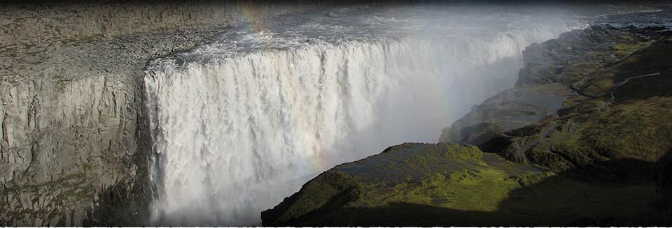
Dettifoss waterfall
Dettifoss Waterfall

Awesome force
Dettifoss is Iceland’s greatest and most majestic waterfall and is part of Vatnajökull National Park. It is also rated as Europe’s most powerful waterfall, based on its magnitude. Dettifoss is 45 meters high and 100 meters wide, and its force is such that the bedrock trembles when hit by the weight of an immense column of white-foaming water.
Dettifoss is in the glacial river Jökulsá á Fjöllum, which emerges from beneath Vatnajökull glacier and runs into Öxarfjörður bay. The annual average flow is 193 cubic meters per second, lowest in winter months but increases in the summer to over 400 m3/s in august. During floods it often reaches well over 500 m3/s but the highest recorded flow was in 1999, measuring 2770 m3/s at Grímsstaðir, 25km up river.
Dettifoss is the center fall in a unique series of waterfalls; about one km up river is Selfoss, and two km down river is Hafragilsfoss.Dettifoss cuts the river at an angle so the scenic experience is quite different depending on which side the waterfall is viewed from.
The west bank of Dettifoss
Road 862 runs on the west side of Jökulsá river between road 85 in Öxarjförður region and ring road 1 in the Mývatn region. From road 1, Dettifoss is accessible by a paved road. A new road 862 under construction will hopefully be fully completed in 2019.
From the parking lot on the west side of the Jökulsá, there is about a 15 minute walk through a desert like terrain of sand and rock to Dettifoss. This makes the view all the more breathtaking when you come to the ridge where Dettifoss appears in all its glory.
Along the ridge are paths and an overview platform with a good angle of Dettifoss. Below the ridge is a bright green dell called Fosshvammur, where grass and moss are constantly watered by the spray of the waterfall. There are steps down and a marked path, which visitors are urged to stay within, as the ground can get wet and slippery. Standing in Fosshvammur, you are at level with the top of Dettifoss and face to face with its awesome power. It is an experience that leaves no one untouched.
From Dettifoss, you can take the marked trail up to Selfoss and from there on back to the parking lot. The circle from the parking lot to Dettifoss and Selfoss and back is about 2.5 km and takes approximately one hour.
The east bank of Dettifoss
Road 864 runs along the east side of Jökulsá river, between road 85 in Öxarfjörður region and main road 1 in the Mývatn area. It is a gravel road, but before the new road 862 on the west side, this is where most visitors came to view Dettifoss.
A turn-off leads to a parking lot from were it is a 10 minute walk. The path leading from the parking lot is a fairly steep and rocky so utmost care should be taken. Down on the flat riverbank there are marked paths and a viewing platform. The view from here is particularly beautiful in the early part of the day when the sun shining from behind lights the spray aglow in all the colours of the rainbow.
A marked trail leads from Dettifoss up to Selfoss which is also well worth seeing. While only 10m high, it is very wide. The hike back and forth takes about one hour.
From the parking lot, there is also a marked trail along the river bank down to Hafragilsfoss, although most people opt to drive down to the parking lot by Hafragilsfoss. While the fall itself is quite smaller than Dettifoss, its surrounding is magnificent for here the canyon is truly grand.
Connect to Edge of the Arctic
Email us
nordurhjari(@)edgeofthearctic.is
Call Us
(+354) 855 1511